From the old records
The history of Pengilfach
Every old house keeps a little of its past in its name, its walls and the paper records left behind. Here is what the public record tells us about Pengilfach and the valley it sits in, and where you can go to look for yourself.
What the name tells us
“Pengilfach” is made of three small, old Welsh words. Pen is a top, head or end; cil is a nook, a sheltered corner, a place of retreat, the same element found in names all over Wales, from Cilmeri to Cilfynydd; and bach (softened here to fach) simply means little. Put together they give something close to “the top of the little nook” or “head of the sheltered hollow.”
It is a fitting name for a place tucked high on the flank of the Sugarloaf, in a fold of the hillside above the Grwyne valley: a quiet, half-hidden corner of ground, which is exactly what the old farmers who named it would have seen.
The parish: Llangenny
Pengilfach lies in the old parish of Llangenny (Welsh Llangenau), a small parochial chapelry in the hundred of Crickhowell, historically in Breconshire and now within Powys and the Bannau Brycheiniog (Brecon Beacons) National Park. The village sits where the Grwyne meets the Usk, a couple of miles east of Crickhowell.
The parish church is dedicated to St Cenau (Keyne), and its registers are among the older ones in the region, with baptisms and marriages reaching back to the late seventeenth century. A Victorian gazetteer of 1868 records that iron founding and paper making were once carried on in the parish, that the village was small, and, tellingly for our story, that the tithes were commuted in 1840. That single date is the key that unlocks the next part.
The tithe map of 1840
For centuries, landholders paid a tithe, a tenth of what the land produced, towards the upkeep of the parish church. The Tithe Commutation Act of 1836 turned those payments in kind into money, and to work out who owed what, every parish in England and Wales was surveyed and mapped. Between 1838 and 1850 the great tithe maps were drawn, the most detailed maps of their day, each with an apportionment schedule listing every plot: its number on the map, the landowner, the occupier, the state of cultivation, the acreage and, more often than not, the field name.
Llangenny’s tithes were settled in 1840, and on that parish map the ground beneath Pengilfach is parcel number 434, recorded with the wonderful old field name Scybour Tyr Ycha. In modern Welsh that is close to ysgubor tir uchaf — the barn of the upper land, or simply the upper-land barn. It is a telling name: long before there were cottages here, this was working farmland on the high ground, with a barn standing on it.
That single field name threads the whole story together. The barn of the upper land became, in time, a farm; and part of that farm became the cottages that stand today.
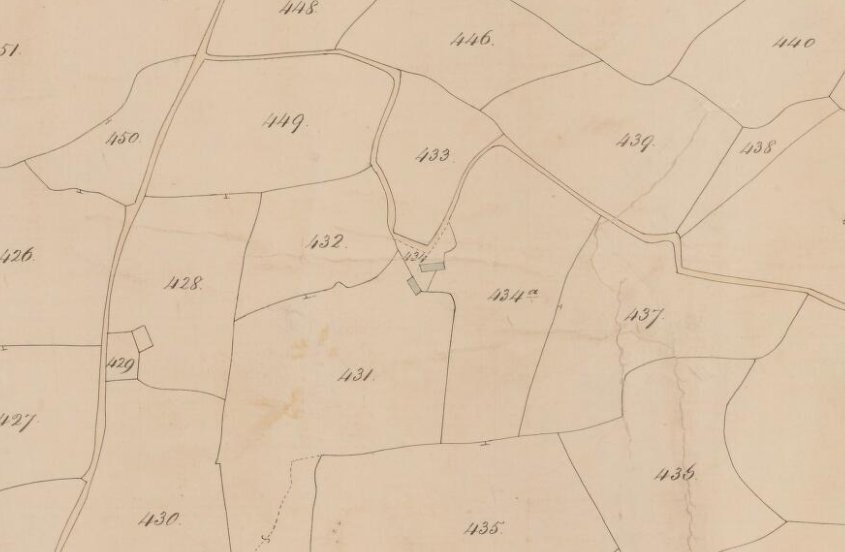
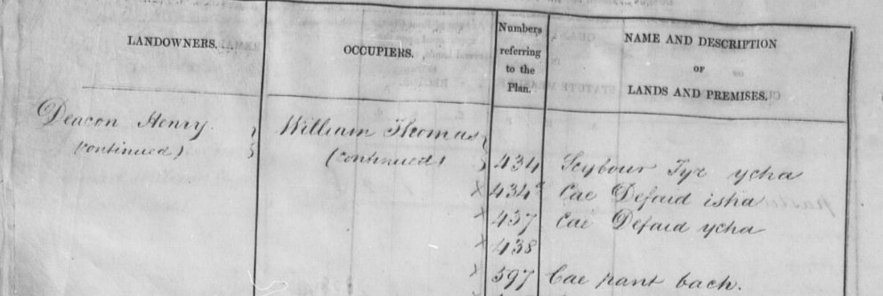
The apportionment schedule that accompanies the map puts names to the land. Around 1840, parcel 434 was held by a landowner recorded as Henry Deacon and worked by an occupier named William Thomas, the same William Thomas whose name runs down the neighbouring entries, farming a little cluster of fields with wonderfully Welsh names: Cae Defaid isha and Cae Defaid ycha (the lower and upper sheep fields) and Cae nant bach (the little brook field). So the barn on the upper land sat among sheep pastures and a small brook, part of a working Welsh hill holding nearly two centuries ago.
The tithe maps and their schedules have been digitised by the National Library of Wales and can be searched, free, on the Library’s Places of Wales website. If you’d like to go looking yourself, the record is public and waiting:
What the old deeds tell us
A run of twentieth-century conveyances, preserved among the title deeds, lets us trace the two cottages back to their beginnings as part of a working farm. In 1950 the property is described in full: the farm and farm lands known as Pengilfach, with its farmhouse, outbuildings and five cottages, together with rights of pasture and common over the Sugar Loaf mountain, some 184 acres in all. The cottages are the pair recorded on the 1920 Ordnance Survey map as enclosure number 171, “Pair of Cottages.”
From there the farm changed hands, and in time the two cottages were sold off separately from it. The farm was sold on in 1957 (by then about 125 acres, with rights of common over both the Sugar Loaf and the Black Mountain), and then in 1960 the two cottages, until that moment part of the working farm, were sold on their own for the first time. Nine years later, in 1969, the cottage known as No. 1 changed hands again, passing to a new household who had moved up from the south-west. Out of respect for privacy we leave the twentieth-century families unnamed here, though their names are all there in the deeds for anyone who holds them.
Running through every one of these documents is the water. Each deed carefully preserves the right to a supply of water from the existing source on Pengilfach Farm, shared with the neighbouring cottage and with the adjoining estate land, together with mutual duties to maintain the pipes and tanks and to make good any damage. The shared spring that the household is still tending today, then, is no recent arrangement: it is written into the very deeds that shaped these cottages, three-quarters of a century ago.
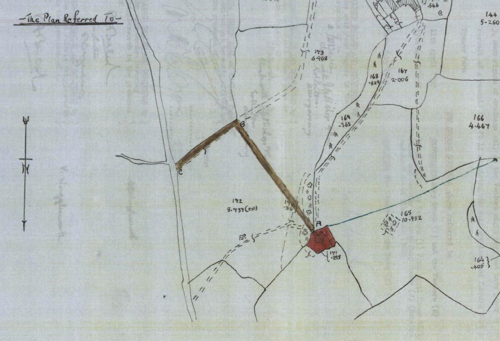
This is the plan attached to the 1960 conveyance, and it is worth a word of caution: it is a rough, hand-drawn sketch, approximate and far less precise than the later surveyed plans. Even so, it tells us something nicely: at that date the two dwellings are drawn as a single shaded plot in one curtilage, named simply “Pengilfach Cottages.” The brown line marks the shared track up to the lane, and the blue line the run of the water supply, the same arrangements the deeds set down in words.
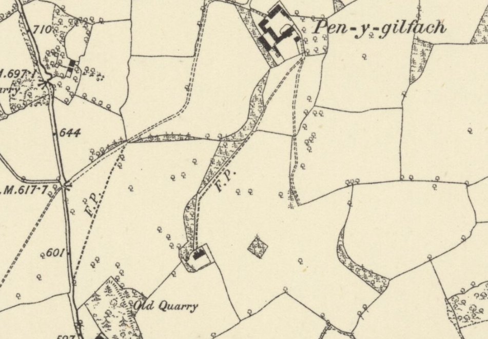
By the time of this 1887 survey the place is named on the map as Pen-y-Gilfach, with its buildings drawn in and the old paths threading up the hillside towards the farm, much the same ways the family still walks today.
Pengilfach and the Pendarren estate
Those same deeds point to something larger. In 1950 Pengilfach farm was sold by the owner of Pendarren Park, the estate just across the valley, and the deeds record Pengilfach as adjoining the Pendarren land and sharing its water source. Local tradition holds that Pengilfach was the estate’s home farm: the farm that fed the great house, with its cottages built for the people who worked the land. The documents don’t use those exact words, but everything in them (the ownership, the shared water, the cluster of farm cottages) fits that story closely.
Pendarren House itself was built in 1876 by John Andrew Doyle, a wealthy man devoted to country pursuits, whose father had edited a London newspaper. It passed in 1905 to a Colonel Rees, a mining engineer from Aberdare, and later to a former under-gardener of the estate who rose to own the place. A grand house like Pendarren needed land, produce and hands to run it, and around the turn of the century a great many local people went into service on such estates. A home farm high on the hill, with a row of workers’ cottages, is exactly what that world required, and exactly what the deeds describe.
Today Pendarren House is an outdoor education centre, and Pengilfach is being restored as a home. But the two places grew up together, and the old thread of water still runs between them.
The valley in pictures
A couple of views of the country Pengilfach sits in, kindly shared by their photographers under a Creative Commons licence.


These two photographs are the work of their named photographers, not of Pengilfach, and remain under their Creative Commons Attribution-ShareAlike 2.0 licence; the links above lead to the originals on Geograph.
Following the record forward
The tithe map is only the beginning. From 1841 the census was taken every ten years, and the returns for Llangenny survive from 1841 to 1901, naming the people under each roof, their ages and their trades. Together with the parish registers and the tithe apportionment, they let us slowly reassemble who lived and worked at Pengilfach across the nineteenth century, a family history written not by us but by the clerks and enumerators of the day.
This page will grow as that work goes on. It is, in its way, part of the same restoration as the walls and the roof: reading the building back into its own past, and making sure its story stands as long as its stone.
Sources: the tithe map and apportionment for Llangenny (parcel 434, Scybour Tyr Ycha) reproduced by courtesy of the National Library of Wales; the twentieth-century conveyances among the title deeds (1950, 1957, 1960 and 1969); the 1887 Ordnance Survey map (out of copyright); the 1868 National Gazetteer of Great Britain and Ireland; the Powys County History Project’s Victorian Crickhowell pages and the published history of Pendarren House; and standard references on Welsh place names. The estate’s “home farm” connection is local tradition supported by the deeds rather than a formally documented title. Photographs of the church and the Sugar Loaf are © Jeremy Bolwell and Philip Halling respectively, via Geograph, under CC BY-SA 2.0. Owners within living memory are left unnamed here out of respect for privacy.